Hurrikánok és tájfunok
Hasznos linkek
>> National Hurricane Center>> Joint Typhoon Warning Center
>> Weather Underground
>> Tropical Tidbits


Estofex így vélekedett tegnap a képzõdményrõl:
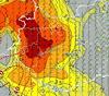
An interesting low pressure system with some characteristics of a tropical (subtropical) storm has developed over 1-2°C warmer SSTs off the coast of Africa during the last days and was already in effect over Canary Islands yesterday. The system is expected to move NE-wards towards extreme SW-ern Iberian Peninsula, affecting southern Portugal by Wednesday morning. Deep convection with heavy rain and strong winds episodes can be expected around the main vortex, but as it stays mostly over the open waters, a threat level was not issued.
Mûhód: Link
Havazás előrejelzés

Utolsó észlelés
Térképek
Radar
Aktuális hõmérséklet
Aktuális szél
Utolsó kép

Mediterrán ciklon hoz csöppnyi tavaszt és kicsivel több telet
Időjárás-változás | 2026-02-18 12:39
Szabályzat