Meteorológiai társalgó
Hasznos linkek (és egy infó)
>> Sat24 műholdképek>> Sat24 Magyarország mozgó műholdkép
>> Magyarországi radarképek archívuma
>>Tippelek az előrejelzési verseny aktuális fordulójában!
>>Rádiószondás felszállások élő követése!
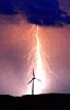
>>Észlelés (közeli villámlás, jégeső, viharos szél, villámárvíz, szupercella, tuba, porördög, tornádó, víztölcsér, viharkár) beküldése a szupercella.hu-nak!
----------
Képek beillesztése esetén kérjük azokat megvágni, reklámok, mobilok fejléce, stb. csak feleslegesen foglalja a helyet és áttekinthetetlenné teszi az oldalt - a vágatlan képek ezért törlésre kerülnek.
Fotózáskor kérjük a mobilt fektetve használni, egy keskeny de magas kép egyrészt szintén sok helyet foglal, másrészt a kép sem túl élvezetes.
Köszönjük az együttműködést és a megértést.
Markowski: ”The LP-CL-HP supercell classes should be viewed as a continuum.”… „HP supercells have a large amount of precipitation within the hook echo region and on the backside of the storm. Visually, the updraft may be difficult to see if it is engulfed in rain.”
De biztosan hallottál már a szupercellák többszöri regenerálódási képességérõl is!?
Persze lehet elõkerül majd egy kép ami ezt cáfolja...de akár ez is történhetett...
De biztosan hallottál már a szupercellák többszöri regenerálódási képességérõl is!?
Persze lehet elõkerül majd egy kép ami ezt cáfolja...de akár ez is történhetett...
Utolsó észlelés
Térképek
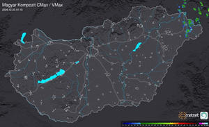
Radar
Aktuális hõmérséklet
Aktuális szél
Utolsó kép

Érdekességek | 2026-03-27 16:50
Szabályzat